


(wikipedia)
Ketchikan è un comune dell'Alaska nel Borough di Ketchikan Gateway, negli Stati Uniti d'America.
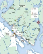
È la cittadina più sud-orientale dell'Alaska ed è posizionata a circa 90 miglia (145 km) a nord della cittadina canadese Prince Rupert nella Kaien Island
(Columbia Britannica) e si sviluppa "linearmente" lungo la costa del Tongass Narrows a sud-ovest dell'isola Revillagigedo (Revillagigedo Island)
di fronte all'isola Pennock (Pennock Island) ed a un'altra più grande (Gravina Island).
A circa 64 km ad est della cittadina si trova il parco Misty Fiords National Monument.
Ketchikan è stata fondata nel 1885 come centro dell'industria conserviera.
Cruise Lines International Association CLIA ALASKA
calendario programmazione attracchi navi da crociera - Clia Alaska
Cruise Line Agencies of Alaska
calendario programmazione attracchi navi da crociera pdf - Cla Alaska
official site città di Ketchikan
porto di Ketchikan official
port map pdf

visit Ketchikan official
Attrazioni
MAPPE
https://www.visit-ketchikan.com/getting-around/ketchikan-maps/


webcams
east-southeast over downtown
https://webcamketchikan.com/mega-view/
west into Berth 3 and straight into Berth 4.
https://webcamketchikan.com/mega-view-cam-2/
east toward downtown Ketchikan
https://webcamketchikan.com/mega-view-cam-3
The Point and looks West / Southwest toward Gravina Island and Ketchikan’s airport
https://webcamketchikan.com/mega-view-cam-4/
gazes West/Southwest toward Ketchikan’s airport
https://webcamketchikan.com/mega-view-cam-5/
view of 3,000′ Deer Mountain and the Thomas Basin boat harbor
https://webcamketchikan.com/mega-view-cam-6/
high on a hillside overlooking downtown Ketchikan
https://webcamketchikan.com/mega-view-cam-7/
Ketchikan è un comune dell'Alaska nel Borough di Ketchikan Gateway, negli Stati Uniti d'America.
È la cittadina più sud-orientale dell'Alaska ed è posizionata a circa 90 miglia (145 km) a nord della cittadina canadese Prince Rupert nella Kaien Island
(Columbia Britannica) e si sviluppa "linearmente" lungo la costa del Tongass Narrows a sud-ovest dell'isola Revillagigedo (Revillagigedo Island)
di fronte all'isola Pennock (Pennock Island) ed a un'altra più grande (Gravina Island).
A circa 64 km ad est della cittadina si trova il parco Misty Fiords National Monument.
Ketchikan è stata fondata nel 1885 come centro dell'industria conserviera.
Cruise Lines International Association CLIA ALASKA
calendario programmazione attracchi navi da crociera - Clia Alaska
Cruise Line Agencies of Alaska
calendario programmazione attracchi navi da crociera pdf - Cla Alaska
official site città di Ketchikan
porto di Ketchikan official
port map pdf
visit Ketchikan official
Attrazioni
MAPPE
https://www.visit-ketchikan.com/getting-around/ketchikan-maps/
webcams
east-southeast over downtown
https://webcamketchikan.com/mega-view/
west into Berth 3 and straight into Berth 4.
https://webcamketchikan.com/mega-view-cam-2/
east toward downtown Ketchikan
https://webcamketchikan.com/mega-view-cam-3
The Point and looks West / Southwest toward Gravina Island and Ketchikan’s airport
https://webcamketchikan.com/mega-view-cam-4/
gazes West/Southwest toward Ketchikan’s airport
https://webcamketchikan.com/mega-view-cam-5/
view of 3,000′ Deer Mountain and the Thomas Basin boat harbor
https://webcamketchikan.com/mega-view-cam-6/
high on a hillside overlooking downtown Ketchikan
https://webcamketchikan.com/mega-view-cam-7/
Allegati
Ultima modifica: